Aerial Triangulation
Aerial Triangulation
VGS has successfully completed various triangulation projects of different sensors like Aerial Frame, Digital, ADS40 and satellite sensors. VGS has qualified and experienced technicians to carry out triangulation. Fast and accurate solution provider in digital aerial triangulation with latest technology by using automated and manual methods. Our staff expertise in using GNSS/IMU data and latest sensors.Strip wise and Block wise adjustments are performed. Robust adjustment is applied to whole block to get the required level of accuracy.
VGS’s methodology combines point selection, point measurement, point transfer and efficient block adjustment in a single process. VGS can take on any job, irrespective of size and complexity. Our technicians are expertise in doing aerial triangulation of corridor mapping, vegetation areas and Snow areas.
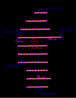
Client is provided with a detailed triangulation and quality report with error analysis and summary of results in Client required formats. Graphical representation of error ellipse for Horizontal and vertical control points is also provided to the client.